 An up-close and personal account of the science behind one of the most fascinating (and sometimes dirty) jobs on earth . . . Many dream of the exciting life of being an archaeologist without realizing the hard work and rough conditions involved in such rewarding career. Works of fiction have often glamorized this profession to a very unrealistic extent. It's time we get our hands dirty and explore the reality of digging up the past. David Crocket State Park |
| Dry Screening: This is the simple procedure in which dirt removed from the plow zone is filtered through a wire mesh to separate larger objects from the loose soil. This helps to collect artifacts that might be overlooked in the initial digging process. Within the plow zone you will often retrieve pieces of artifacts that have potentially churned around in the soil for ages. They would then be bagged along with information of the unit location, approximate depth, and date of discovery. These artifacts will now be off to the archaeology lab to be cataloged and stored appropriately. | 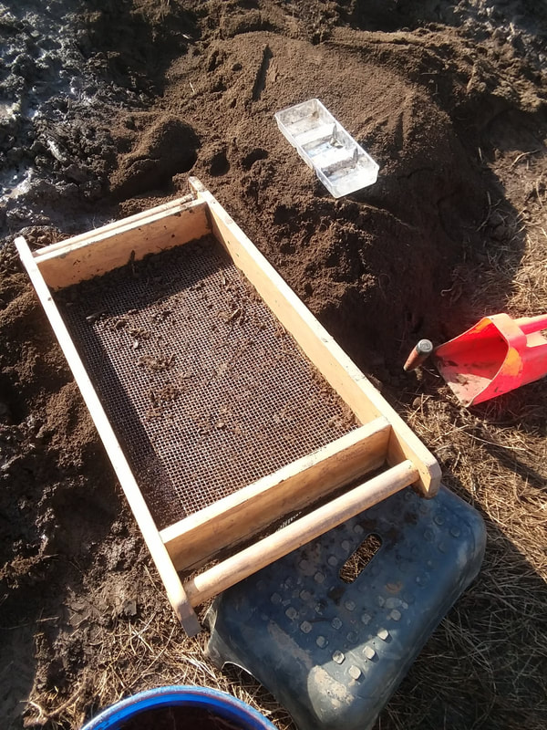 |
| Wet Screening: This type of sifting is typically reserved for the undisturbed soil that lies below the plow zone. Here you can see we were using a water hose to wash away the compacted soil in hopes of revealing artifacts. During this process, we were specifically looking for beads that could easily be overlooked due to being masked with dirt. The discovery of beads was important at this site, as it helped signify the potential of a trade route with other natives as far away as The Great Lakes. | 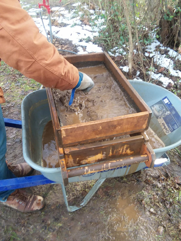 |
On this specific section of ground, we recovered some very impressive pieces of pottery. This would have most likely been a native settlement from around the time of European contact. We can speculate this timeframe from the occasional bullet that was also unearthed within the same layers of the artifacts.
The science of determining the age of an artifact based on other objects found within the same layer of soil is referred to as stratigraphy.
The David Crocket site was satellite to a much larger project that was documented under the title "Secrets of the Nolichucky", which can be found on YouTube.
Fort San Juan at Joara
aka "The Berry Site"
North Carolina (2021)

During the mid 1500s Spanish conquistador Juan Pardo led his troops into western North Carolina. It was at the Native American village of Joara that he would establish the first permanent European settlement of the inland regions of the Americas.
My main focus on this project was to gradually dig through the surface layer to strip away the plow zone of my assigned unit. The removed dirt was then filtered through a screen in search for artifacts. As the plow zone is removed you will begin to notice changes in soil color which signifies the undisturbed layers below. It would now be time for us to begin troweling to further outline those layers that have remained intact for hundreds of years. Soil from these layers would now ne sent to the wet screening station to insure that nothing is overlooked.
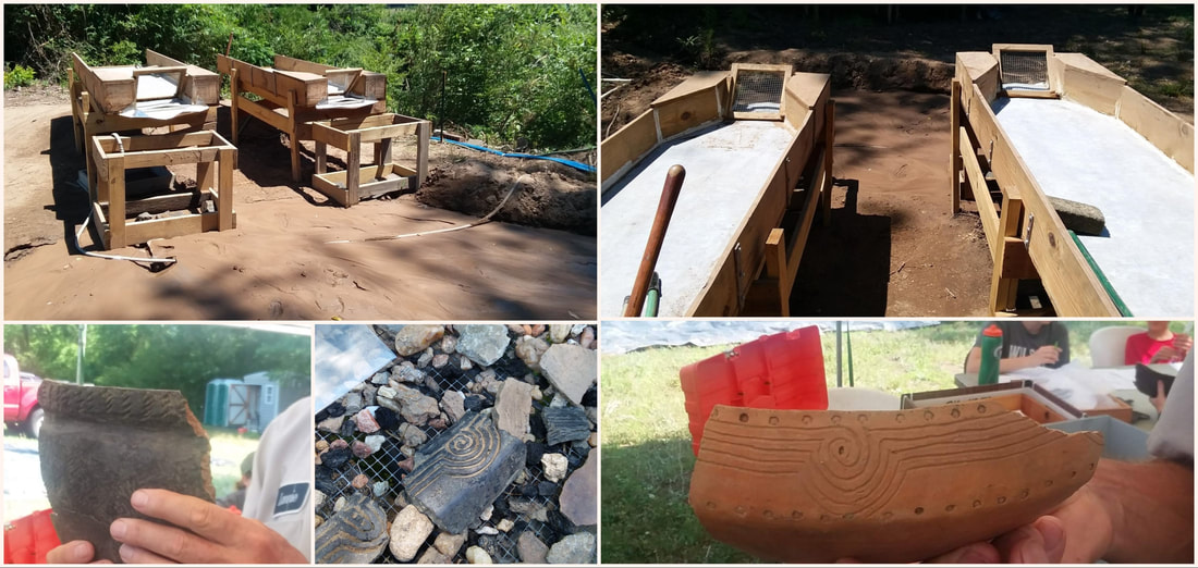
Screening for Artifacts
While we used a similar technique for dry screening on this site, the wet screening was much more sophisticated here. Water was pumped from the nearby creek and into a sleuth device that had been constructed by one of the local volunteers. A generator was need to produce electricity for the pump, as there were no utilities on site. This was a great example of how each location may provide obstacles that will require a bit of ingenuity to overcome in a sometimes challenging environment.
Once the plow zone is removed, you will begin to notice features marked by color variations across the unit. These are often created by fire hearths and refuse pits but may also outline the placement of buildings. Circular holes that have long since been refilled may signify the post holes from a fence or wall. After all loose soil is cleared the unit is then mapped and photographed.
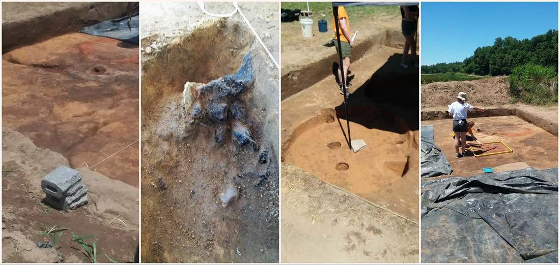
Archaeological Features
Archaeology is often described as a destructive science. This is true because once an artifact is removed from the ground it cannot be accurately replaced. For this same reason, areas that have been excavated are thoroughly mapped with any findings documented in their exact locations. The photo above shows two types of mapping that are used to collect important information. A view from above involves grid mapping which divides the site into units, while a profile map captures the stratigraphic layers of the soil.

Mapping the Site
This interesting site, hosted by North Carolina's Warren Wilson College, provides amazing fieldwork opportunities for students from many other participating universities and some international institutions. Volunteers are also welcome to sign up for a non credit educational experience. The project takes place each summer over a one month period broken down into one week segments.
Other opportunities like this can be found at the website of
Archaeological Institute of America
Archaeological Institute of America
Though the pandemic has put a damper on many of these projects, I am determined to continue this story as I search for more experiences in archaeological fieldwork.
Stay Tuned !!!
Stay Tuned !!!
You may also enjoy my article on
Appalachian Archaeology
Appalachian Archaeology
0 Comments
Leave a Reply.
Author :
Chris J. Baxter ("Siege") is an experienced world traveler with backgrounds in Anthropology, Archaeology, and Tourism. He also tends to display an unquenchable thirst for adventure.
You can search for other interesting articles below!